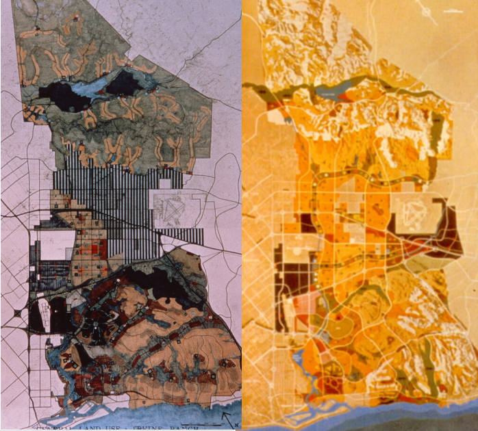
Left to right: the 1962 plan by Pereira & Associates and the 1970 plan by Irvine Company staff, neither of which was adopted by any governmental jurisdiction, but which reflect the company’s thinking at the time of their drafting.
1957 to 1960
A massive, statewide expansion of public higher education spurred land-use planning for 93,000-acre Irvine Ranch. In June 1957, the University of California Board of Regents voted to establish three entirely new general campuses across the state to handle surging population growth; these three campus allocations would ultimately materialize as UC Santa Cruz, UC San Diego, and a third site in the southeast Los Angeles-Orange County region (Forsyth, 2005; University of California, Irvine, n.d.), (Watson, 1960).
The Regents commissioned renowned architect and planner William L. Pereira and his associates to serve as Master Architect to scout, analyze, and select the optimal location for this third regional site (Irvine Standard, 2020). After reviewing 21 potential sites, Pereira steered the university system toward the Irvine Ranch's massive landholding (University of California, Irvine, n.d.). After much internal debate, The Irvine Company transferred approximately 1,000 acres of land to the university system for $1 to become the campus for the University of California, Irvine.
The Board of Regents accepted the land transfer on a strict condition: The Irvine Company had to commit to an integrated planning concept for at least 10,000 acres surrounding the intended campus to forge a symbiotic "town and gown" community (University of California, Irvine, n.d.-a). To fulfill this university-mandated condition, The Irvine Company formally commissioned Pereira's firm in 1960 to expand his campus concepts into a macro-level master plan for the surrounding city.
1960 to 1962 - The original Pereira plan for the ranch
Recognizing the immense potential of building a new town alongside a research institution, the Irvine Company expanded Pereira’s charge to include the entire ranch. The resulting 1962 Irvine Ranch General Plan established a tripartite framework, dividing the ranch into northern, central, and southern sectors. Pereira’s planning vision preserved some agricultural uses in the ranch's flat central valley, celebrated for its highly productive lima bean fields and Valencia orange orchards (Irvine Historical Society, n.d.).
However, the Orange County Board of Supervisors never formally adopted the 1962 plan. The 1962 iteration served as a non-binding conceptual and corporate master plan. Although widely celebrated and serving as a unified vision for the university and the company, it lacked legal jurisdictional authority.
1962 to 1964 - South Irvine Ranch General Plan
Irvine Company planners quickly began refining the 1962 plan. In 1964, the Orange County Board of Supervisors granted the ranch its first official jurisdictional approval. Rather than adopting a ranch-wide blueprint, the county formally adopted the South Irvine Ranch General Plan in 1964, approving only the Southern Sector (Irvine Historical Society, n.d.).
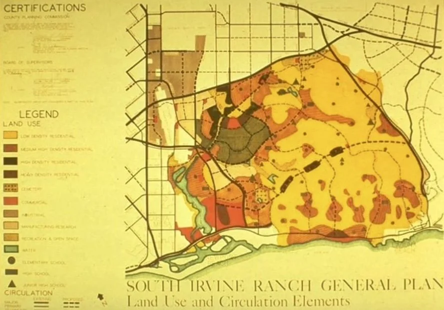
The Orange County Board of Supervisors approved the South Irvine Ranch General Plan in February 1964. (Griffin, 1974).
The 1964 South Irvine Ranch General Plan did not address agricultural uses in the Central Sector. At that time, the company leadership viewed agricultural operations as an essential, revenue-generating transitional use (Places Journal, 2014).
While the plan adopted by Orange County was limited to the Southern Sector and to an area of what was then called the Irvine Industrial Complex north of the I-405 freeway, Watson and Treviño began to adjust Pereira's underlying ranch-wide master plan framework:
Southern sector infrastructure: The 1964 modifications formalized the specific layouts for coastal suburban tracts adjacent to Newport Beach, accelerating commercial master planning for major retail and office nodes like Fashion Island and the initial 10,000 acres orbiting the university (Irvine Historical Society, n.d.; Irvine Standard, 2022).
Internal ranch-wide planning: While the 1964 county approval was geographically limited, the company's internal planning team began mapping transit lines and utility pathways north toward the rugged foothills (Stockstill, 2024). Work in this area served as corporate roadmaps but lacked jurisdictional backing.
Administrative shift: Operationally, the 1964 revisions phased out Pereira’s firm from administrative control of planning (Irvine Historical Society, n.d.). The Irvine Company’s internal team took over execution, translating utopian design concepts into economically viable, phased suburban villages (Places Journal, 2014).
1965 to 1973 - 10,000-acre coastal area
At the same time as the layout of inland villages, the company began detailed architectural and master land-use planning for the ranch's 10,000-acre coastal portion of the southern sector in the mid-1960s (Newport Coast History, n.d.). This is an area of rugged hills and canyons that would eventually become known as Newport Coast.
The company's in-house planners developed initial concept drafts that bore little resemblance to the lower-density enclaves built decades later. Influenced by international tours of European resort destinations, the mid-1960s blueprints proposed a highly urbanized, Mediterranean-style riviera framework (Newport Coast History, n.d.). This early schema slated the coastal ridge lines for 50,000 residential units, some high-rise structures, and a quadrangle of premier luxury resort hotels hugging the coastal bluffs.
When the Irvine Company synthesized its overarching general plan updates, it bundled these luxury resort frameworks directly into the broader 53,000-acre development mapping profile. However, because the coastal sector remained unincorporated, fell outside the centralized inland valley infrastructure development, and fell under the jurisdiction of the California Coastal Commission it established in 1972, it followed a distinct planning path. The initial density proposals sparked deep concern among emerging regional environmental coalitions, laying the groundwork for a highly litigious gridlock that effectively froze physical breaking of ground on the coastal parcels throughout the 1970s and beyond. (Online Archive of California, n.d.).
To try to break this escalating jurisdictional and environmental gridlock, The Irvine Company initiated the Multi-Agency Planning Process (TICMAP) in 1973 (California Coastal Zone Conservation Commission, 1976). Initiated as a joint advisory panel, TICMAP brought together corporate executives, Orange County regional planners, representatives from the neighboring cities of Newport Beach, Laguna Beach, and Irvine, and officials from the South Coast Regional Coastal Commission. For more than two years, the advisory process attempted to establish a consensus-driven land-use roadmap for the coastline.
Unfortunately, TICMAP ended inconclusively and in a fragmented manner in 1976 (California Coastal Zone Conservation Commission, 1976). The process buckled under unresolvable friction between the Irvine Company's development concepts and the low-density land uses and natural-area preservation demanded by state coastal authorities.
1965 to 1970 - An attempted ranch-wide plan
As the earliest residential villages (such as Eastbluff, University Park and Turtle Rock) achieved rapid market success in the mid-1960s, the region's economic reality changed dramatically (Irvine Standard, 2022). The massive population influx caused surrounding property appraisals to skyrocket, imposing severe property tax burdens based on speculative "highest and best use" valuations rather than actual farming yields (Forsyth, 2005).
To navigate these fiscal pressures, the Irvine Company deployed a dual spatial strategy utilizing California's newly enacted Land Conservation Act of 1965, widely known as the Williamson Act (Irvine Historical Society, 2020). Rather than letting the tax assessor's escalating bills force immediate, premature land sales across the entire property, the company proactively secured county approval to place more than half (49,000 acres) of the ranch into agricultural preserves under the Williamson Act in 1969 (Irvine Historical Society, 2020). This protection reduced tax assessments to property values based on agricultural productivity rather than development potential, allowing the company to retain the rugged northern mountains and perimeter grazing lands as open placeholders to be developed or preserved in an orderly, controlled, long-term fashion (Irvine Historical Society, 2020).
Crucially, the land left entirely outside this 1969 Williamson Act preservation zone was the flat central valley floor (Pereira’s Central Sector), which company leadership earmarked for near-term master-planned urbanization (Irvine Historical Society, 2020). Because the company refused to tie up this prime valley center in rolling ten-year Williamson Act development restrictions, tenant farming operations across the flat central basin were phased out and ended by 1969 (Irvine Historical Society, 2020).
When the company finalized its updated planning exhibit for the Irvine Company General Plan of March 1970, it deleted active agricultural allocations in the central sector. The flat plains were redesignated to maximize contiguous urban development, creating an expanded 53,000-acre development footprint that combined the southern and central sectors. This updated layout accounted for 24 distinct residential villages—including the initial concepts for the lake-centered Woodbridge community—alongside 7,500 acres for commercial use and 2,400 acres for parks (Irvine Company, 2021).
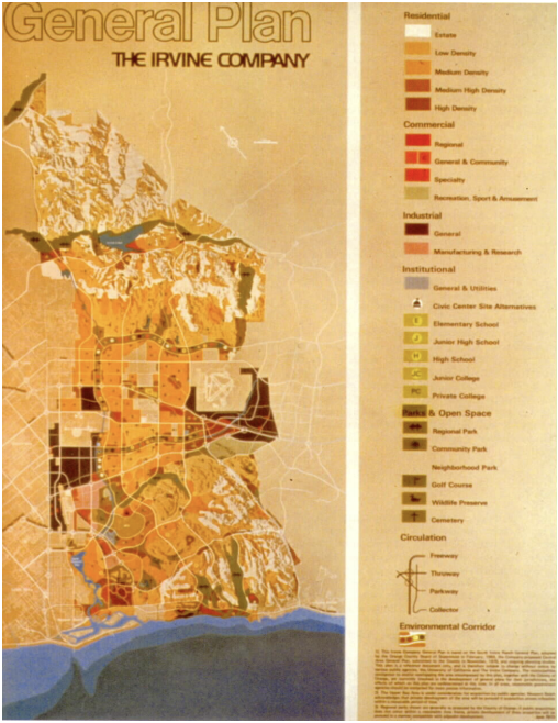
The Irvine Company submitted the 1970 General Plan to Orange County, but it never adopted it. (Irvine Historical Society, 2020).
Seeking a permanent, macro-level layout for the remainder of its land, the Irvine Company delivered this revised 53,000-acre master-plan expansion to county planners on March 19, 1970. However, the Orange County Board of Supervisors never formally adopted the 1970 plan. While the county had been highly accommodating during the 1964 South Irvine Ranch General Plan approvals, the political landscape had shifted by 1970.
County supervisors grew skeptical of granting a single private real estate corporation unchecked, unilateral planning control over a territory slated to become the continent's largest master-planned city. Meanwhile, neighboring municipalities launched "annexation raids" to seize the lucrative tax base of the developing Irvine Industrial Complex, throwing the county's unified regional planning process into bureaucratic gridlock (Stockstill, 2024).
1971 to 1973 - Interim City of Irvine General Plan
The lack of a stable, community-first plan under county oversight ultimately served as the political tipping point for local residents. Believing county planners were ill-equipped to balance developer interests against community-driven growth concerns, 30 local village homeowner associations banded together (Stockstill, 2024). This culminated in a rapid, protectionist counter-movement. On December 21, 1971, local residents voted 2-to-1 to incorporate the City of Irvine (Irvine Company, 2021).
After incorporation, the newly established City of Irvine decisively assumed planning authority over much of the Irvine Ranch. Fledgling city council members sought to channel the rapid development pressures of the 1970s, rather than let it become a purely private venture (Irvine Community News and Views, 2020).
Because the independent city could not instantly draft a massive, comprehensive master plan from scratch, the city council adopted an interim General Plan layout in December 1973 (City of Irvine, 1973). This transitional planning document served as a vital mechanism, allowing the city to legally issue development approvals—including individual tract maps, environmental impact evaluations, and incremental zoning amendments—while citizen committees worked on a permanent master plan framework.
Under this 1973 interim document, the city formally initiated massive, high-profile projects like the Village of Woodbridge. The Irvine Company used these interim approvals to begin physical grading, excavate the community's signature twin artificial lakes, and establish early loop roadway infrastructure by 1975, ahead of the community's first residential lottery sales in June 1976 (Irvine Standard, 2022).
1973 to 1976 - City of Irvine General Plan
Rather than reverting to William Pereira's original 1962 model of a permanent central valley agricultural reserve, the new city recognized the region's overwhelming market velocity. Between 1972 and December 1973, the city adopted preliminary elements of its General Plan, allowing the Irvine Company to move forward with the 1,710-acre Village of Woodbridge, which opened in 1976.
This historic process culminated in the City of Irvine's formal adoption of the comprehensive General Plan in 1976 (Stockstill, 2024). By enacting this document, the City of Irvine—not Orange County—deleted the central sector agricultural land-use designations. The City redesignated agricultural land uses on flat terrain to allow substantial residential and commercial development.
Culmination of two decades of planning
The City of Irvine adopted its General Plan in 1976, just as bidding for the Irvine Company's acquisition began, leading to its sale in May 1977. (Lindsey, R. 1977). This ended the first two decades of master planning for the Irvine Ranch. After the Irvine Company sale closed in July 1977, the new ownership took control and installed a new executive team (“Irvine picks Kremer as its new president, " 1977).
References
California Coastal Zone Conservation Commission. (1976). California Coastal Zone Conservation Act of 1972: Annual report to the governor and the legislature. California State Legislature. https://www.govinfo.gov/content/pkg/CZIC-ht393-c2-c33-1975/html/CZIC-ht393-c2-c33-1975.htm
City of Irvine. (1973, December). City of Irvine Interim General Plan. City of Irvine Community Development Department. https://cityofirvine.gov/sites/default/files/legacy-documents/civica-35278-4.9_land-use.pdf
Forsyth, A. (2005). Designing suburban futures: New towns for the twenty-first century. University of Pennsylvania Press.
Griffin, N. M. (1974). Irvine: The Genesis of a New Community. Urban Land Institute.
Hess, A. Places Journal. (October 2014). Discovering Irvine. Places Journal. https://placesjournal.org/article/discovering-irvine/
Stockstill, M. (2024, June 4). Stockstill: A short history of the Irvine General Plan. Voice of OC. https://voiceofoc.org/2024/06/stockstill-a-short-history-of-the-irvine-general-plan/
Irvine Company. (2021, May 16). At 50, New City of Irvine is evergreen. The Irvine Standard. https://www.irvinestandard.com/2021/at-50-new-city-of-irvine-is-evergreen/
Irvine Community News and Views. (2020, December 28). Five-part series: Irvine through the decades — The beginning of our planned community in the 1970s. irvinecommunitynewsandviews.org
Irvine Historical Society. (2020, October). Irvine Ranch gives way to urban development. https://irvinehistory.org/wp-content/uploads/2020/10/Irvine-Ranch-gives-way-to-Urban-Development.pdf
Irvine picks Kremer as its new president. (1977, June 29). The New York Times. https://www.nytimes.com/1977/06/29/archives/irvine-picks-kremer-as-its-new-president-coast-developer-says.html
Irvine Standard. (2022, November 9). A pioneer in master planning. The Irvine Standard. https://www.irvinestandard.com/2022/a-pioneer-in-master-planning/.
Lindsey, R. (1977, May 21). Taubman-Allen Group Is Winner Of Irvine as It Tops Mobil’s Offer. https://www.nytimes.com/1977/05/21/archives/taubmanallen-group-is-winner-of-irvine-as-it-tops-mobils-offer.html
Newport Coast History. (n.d.). Newport Coast history: Irvine Ranch to modern communities. https://newportcoastoc.com/newport-coast-history
Online Archive of California. (n.d.). Friends of the Newport Coast records, circa 1976-2011. California Digital Library. https://oac.cdlib.org/findaid/ark:/13030/c88k7c76/
University of California, Irvine. (n.d.-a). Land agreements between the University of California and the Irvine Company. UCI Libraries Special Collections & Archives. https://oac.cdlib.org/findaid/ark:/13030/kt887006q1/
University of California, Irvine. (n.d.-b). William Pereira, architect. UCI Libraries Special Collections & Archives. https://special.lib.uci.edu/collections/anteater-chronicles/architecture/william-pereira-architect
Watson, R. L. (1997, April 30). Land use map from the South Irvine Ranch General Plan [Map]. Raymond L. Watson papers (Collection MS-R120). Orange County Regional History Collection, UC Irvine Libraries, Irvine, CA, United States. Calisphere. https://calisphere.org/item/ark:/81235/d84s4m/
Watson, R. L. (2006, February 1). 1960: Planning the Irvine Ranch begins. Watson (Raymond L.) papers, Orange County Regional History Collection. UC Irvine Libraries, Irvine, CA. https://calisphere.org/item/ark:/81235/d8101m/